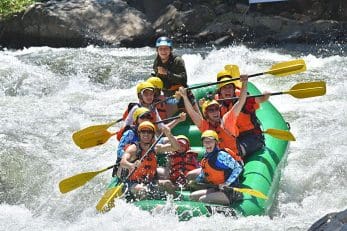
Drift boating is a unique experience that provides a superb platform for fishing and sightseeing. Although popular on California rivers such as the Trinity, Feather and Lower American in Sacramento, with one notable exception, drift boats are absent from the South Fork of the American River in Coloma.
The reasons are several, but essentially they boil down to one, rocks. Unlike a rubber whitewater raft, a drift boat is made of rigid material such as aluminum, wood, or rarely, fiberglass. If you hit a rock the wrong way with a drifter, the damage can be catastrophic. Years ago a skilled local carpenter here in Coloma spent two years building a beautiful drift boat out of wood, and when it wrapped around Gunsight rock in Troublemaker Rapid on its maiden voyage, it was removed in pieces.
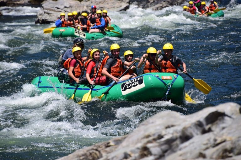
With this in mind, I am always a little nervous when I put Mother Lode’s elegant, maroon colored drift boat into the river at Henningsen Lotus Park, as I prepare to run the four miles of the Middle Reach down to the Mother Lode Camp. The anticipation is exhilarating, so I am always excited to begin! Evening runs are most scenic, and as the run passes Camp Lotus with Barking Dog Rapid, Canadian geese go by honking loudly overhead. There is now a stretch of flat water above Current Divider. By this time I have sighted a Blue Heron, am not sure whether that was a Golden or a Bald Eagle, spied several species of hawk, several deer, a flock of turkeys, a Merganser leading her clutch of ducklings, and several American Dippers doing their characteristic up-and-down dance on partially submerged rocks. I also wondered if that was a beaver slapping its tail upstream? Finally, as I float past Rivers Bend, I approach the only Class III rapid on this run and one of the longest on the South Fork, Highway.
Here the river turns sharply westward toward the evening sun. A low-pitched growl becomes progressively louder as the river gradually transforms itself from a smooth, glass-like surface into a series of riffles, then into churning waves of whitewater. Submerged rocks reveal themselves by creating upstream pointing Vs of current, and just as avoiding these becomes a priority, the setting sun blinds me.
I blink hard, narrow my eyes to slits, and search for the through line. This is the downstream pointing V of current that reveals the deepest and safest channel. Meanwhile, as the gradient in the rapid steepens, the current accelerates and draws the boat toward danger. Mind you, this is nothing personal, it is simply the river following gravity toward its origin, the ocean. I like to remember that the river is born there as evaporating mist, which condenses as clouds, then falls as rain and snow, and finally comes to rest in the deep snowbanks of the Sierras. During the Winter, the river bides its time, waiting until Spring to complete its cycle as ice-cold, crystal-clear snowmelt. It then finds its way into streams and swells to reform, crests dams, falls over waterfalls, forms meanders in valleys, and finally arrives at the crooked place in the river known as Highway Rapid, the home of the Mother Lode River Center.
This highway is the Old Coloma Road, or State Highway 49, in the historic Coloma/Lotus Valley. This is not just any road. Once a dirt, two rut wagon track, this is the road that carried Wells Fargo stagecoaches as they connected the site of gold discovery at Sutter’s Mill in Coloma, to Grass Valley and Nevada City to the North, and to Sonora and the Yosemite Valley to the South. It is the road that joined the Golden Chain of settlements referred to as the Mother Lode, and hence the River Center’s name.


I am now midway down Highway and my attention is focused on the ledge that forms a small waterfall across two thirds of the river. This is a place not to be trifled with, and several strong oar strokes are required to position the boat with bow downstream to run the drop. I remember this place for many reasons. The first that comes to mind is a morning shrouded in mist. My older daughter, Emily, is fishing from her favorite eddy just below this drop on river right. She is tiny and is dwarfed by her fishing pole, and as she reels in what may be a large fish tugging at the line, the torpedo shape of a trout appears. There is a second larger shape immediately behind it that is too large to be a fish. At the last minute the second shape darts away, it is a River Otter! Like Emily, it has pursued its catch until the bitter end, only to disappear as quickly as it came. The amazement we both felt in that moment over thirty years ago remains vivid even now. In fact, just a few days ago my 14-month-old grandson, Will, while playing near that same eddy, spotted two otters working their way up against the current searching for food. To complete this circle, all that remains is for little Will to be here in my place, pulling hard on these oars.


And I need to pull hard. The boat has drifted out of position, and daydreaming is about to bring about serious trouble. I arch my back and thrust with my legs against the foot brace to gain additional leverage. The drift boat with its shallow draft and flat bottom responds crisply and surfs rapidly out of harm’s way into a hidden eddy. This is Cassidy Bell’s Eddy, and I take a deep breath and rest my elbows on the oars as the boat settles into its slack water, and my mind wanders again.
I imagine it was on an evening similar to this one that Cassidy’s Eddy earned its name. Decades ago Cass, as Cassidy Bell was known in those days, was a young river guide enjoying a similar evening run in his kayak. As he eddied out, he looked for a better place to view the sunset. A high promontory of granite caught his eye. He scrambled up to it, working his way through an intense thicket of blackberries. As he swept aside the thorny vines he noticed something remarkable- several deep holes in the granite which could only be one thing- bedrock mortars.

These are depressions created by the Native Americans with Chawsee, or grinding rocks, used to pound acorns gathered from the huge oaks nearby into meal. This discovery was very exciting, yet he did not share it with anyone. Identifying strongly with Native American values himself, Cass was concerned others would not treat this place with the same reverence he did. He kept his discovery a secret– for the entire river season! He brought a large wooden plank and placed it next to the stones, so he could sleep next to them, and to act as their guardian. No one knew where Cass went at night. Only when the season ended did Cass share the existence of this place with me.
As we explored the granite outcropping together, we were amazed to find other bedrock mortars, over thirty in total. One was over 8 inches in diameter and over 16 inches deep, suggesting it was at least a thousand years old. We realized that this place was an ancient Nisenan village. This mass of granite not only provided Nisenan women a panoramic view of the river as they pounded their acorns, we imagined them watching their men fish for salmon in the river below. Now, as I sit eddied out in Cassidy’s Bell’s Eddy above the stones, I remember Cass and appreciate his special way in the world. It is a way of respect.


To the Mother Lode Guides who today call it home, the River Center and Highway Rapid continue to be such a revered and respected place. Sitting at the river’s edge on a busy weekend, there are perches, unscheduled swims, an occasional wrap and a steady supply of Rescue 3 Swiftwater Rescue practice scenarios that provide a show worthy of an action movie! Yet there is a deeper meaning here that our river family cannot easily describe. Although we choose to share our river home with others, we know that like the Earth itself, this place is alive and sacred. It deserves the reverence that all nature deserves on this, the Blue Planet, the only place we are certain there is life in our vast and ever-expanding Universe.
I have tarried in Cass’s Eddy long enough. It is time to descend Highway Rapid and experience a moment of truth. My goal is not to be part of the drama, but on the contrary, to provide a display of skill that creates a moment of beauty. This is not particularly easy as it turns out.


The Mother Lode eddy is formed by a large, partially submerged rock that often upsets rafts, kayaks and other craft, embarrassing the best of guides. To Mother Lode’s drift boat, however, this rock is not merely a challenge, but a serious threat. A drift boat has no floatation tubes, no self-bailing floor or pliable rubber sides like a raft. Rather in this case it is made of unforgiving fiberglass, and should it broadside the rock in the eddy, it will likely sink and be destroyed. So now comes the crux, the moment of truth in which the wager against nature is won or lost. How does it end? That is to be determined, and if you are interested in finding out how your own story might unfold, feel free to inquire after a ride. Perhaps drifting down Highway Rapid could be in your future!


***Highway is the last and largest rapid on the four-mile Middle Reach of the South Fork of the American River that begins in Coloma and ends at Mother Lode Camp. It is a Class II run with one Class III rapid, that is, Highway. Long ago the Mother Lode guides named this run The Bio in honor of another river, the Rio Bio Bio, located in Chile. That majestic river run was destroyed by a dam. It is a fate that has thus far been prevented on the South Fork, and the Mother Lode guides have played an important and inspired role in saving the South Fork and 14 other California rivers from destruction. Whether they share it with you in our drift boat, a self-bailing whitewater raft, a pack raft, or some other craft, our wager is that the grace and beauty of The Bio, and the other runs on the South Fork, the Chili Bar and the Gorge, will convince you that keeping our rivers flowing and alive is worth the struggle.***